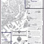
THE LYME REGIS MILLENNIUM MAP
The Lyme Regis Millennium Map is unique.
It was designed and researched by local historian Peter Russell and printed on parchment paper by David Endersby.
It is considered a valuable collectors item and an ideal piece of memorabilia.
Individual houses and buildings are characterised, replicating the charm of Lyme Regis, Dorset in the South West of England, UK.
Incorporated in the map / chart is a descriptive history of Lyme Regis from 774AD to date; explaining such subjects as the Cobb, Lyme’s connection with Bermuda, smuggling, Mary Anning, Lassie and many others.
Below is a crude replication of the east portion, which by no means does the map / chart justice, together with 2 details extracted from the map or chart.
Scan of east portion of Lyme Regis Millennium chart in grey scale (reduced),
showing the events in history.
Detail from top right hand corner of Lyme Regis Millennium map / chart showing
an example of the history portrayed by this map. An ideal collectable.
Detail of the Cobb from the Lyme Regis Millennium map / chart.
A memorabilia item


